 Sediment, seemingly a simple parameter, turns out to have complex economic and environmental links to much of what goes on in the entire watershed.
The opinions expressed here are those of the author alone and not of the Board of Directors of the Hudson River Environmental Society.
PCBs, mercury, dioxin, – some things we don’t want at all in the Hudson River. We might argue over how much to spend on reducing these substances but it’s universally agreed that less is better than more. Production bans and use restrictions from the Toxic Substances Control Act and the Clean Water Act as well as state laws and regulations have greatly reduced these toxic substances. Sediment, on the other hand, presents a more complicated issue. From the standpoint of commercial and recreational navigation, sediment is a problem. Contaminants and availability of disposal sites complicate and adds expense to dredging. Sediment in the Hudson comes from the landscape. The material depositing in shipping channels and berths originated in tributary channels and from surface erosion, often from disturbed soils. Eroding stream banks degrade habitat and, occasionally, damages stream-side infrastructure. Erosion represents loss of environmental capital. On the other hand, maintenance of channel morphology in the face of normal erosion and sea level rise requires fresh sediment. It is unclear whether we have the ability to significantly reduce sediment loads to the Estuary.
The Port of NY/NJ, the third largest in the county and the largest on the East Coast, employs 279,200 people regionally (46,400 in NYS) and pays$5.2 billion in taxes ($1.4 billion in NYS).[1] By 2014 the Autoridad del Canal de Panama will spend $5.25 billion building a third set of larger locks. Containerships carrying up to 4,800 TEUs (twenty-foot equivalent units) can pass through the current Panama Canal. The new locks will permit passage of 13,000 TEU vessels. Deepening portions of New York Harbor to 50 feet will accommodate these larger ships but by the time the canal and port improvements are in place 18,000 TEU ships will begin sailing between Asia and Europe.
Operation of the port requires safe and economic disposal of dredge spoil from deepening as well as maintenance dredging. The deepening projects will produce 50 million cubic yards (cy) of dredge spoil 21% of which is chemically contaminated mud. Maintenance dredging generates an average of 1.5 million cy each year. Of this, 45% needs dewatering and other processing for various kinds of upland disposal. Disposal costs range from $8-18 per cy as clean surface cover for ocean disposal (at the Historic Area Remediation Site - HARS), $30-45 per cy for creation and replenishment of marsh islands in Jamaica Bay, $35-46 per cy for disposal in the Newark Bay Confined Disposal Facility, $50-70 per cy for development of artificial fishing reefs, and $60-100 per cy for processing and upland disposal. The overall cost of dredge disposal ranges from $45 to $52 per cy. The budget for maintenance dredging is $9 per cy.[22] Put another way, the excess cost of dredge disposal, beyond the appropriated $14 million per year, is $56-66 million per year. The total cost of managing sediments from the port out to 2065 is estimated at from $7 to $12 billion.[23]
Sediment management is greatly hampered by the degree to which issues cross political and interest boundaries. Remediation or restoration projects are often constrained by the wishes of landowners and local governments unimpressed by the “big picture” or expert advice. In 2008 the New York-New Jersey Harbor Estuary Program accepted 45 recommendations from the Regional Sediment Management Plan for dealing with sediment quality, sediment quantity, and dredging management. Central to the recommendations was the appointment of Sediment Advocates in New York and New Jersey with the authority to coordinate sediment-related actions between agencies. [18] To date, neither state has designated Advocates.
Landscape modifications affect the rates of sediment delivery. Nineteenth Century logging, roads, and agriculture resulted in greatly increased, 20 fold in some estimates, sediment production. Twentieth Century reforestation, abandonment of steep-sloped marginal farms, agricultural conservation, and dams reduced sediment loss. Excavators and other power machinery let property owners and highway departments shove streams around sometimes in ways inconsistent with sound hydrology. Failure of 19th Century mill dams, jeep and ATV trails, impervious surfaces from suburban sprawl, and more intense storms from climate change increase sediment erosion. Invasive and persistent Japanese knotweed (Fallopia japonica) [2] contributes to stream degradation by out-competing native species which provide better soil retention as well as forage for wildlife.[personal communication, J. DuBois, Greene county Soil and Water District 11/30/2011] Differences in landscape characteristics lead to quite different rates of sediment production. The Upper Hudson exhibited a loss of 53 tons per square mile per year while the Mohawk Basin showed almost three almost three times that, 149 tons per square mile per year.
Dams profoundly alter stream morphology by trapping sediment, and sometimes toxic chemicals, releasing sediment-starved water, changing the sediment grain size, changing the hydrograph, and water temperature.[11] Dams along the Colorado, Nile, Indus, and Yellow Rivers have effectively stopped sediment discharge, whereas previously these four rivers alone accounted for 10% (1.5 BT per yr) of sediment flux to the global oceans.[21] A report from the New York Academy of Sciences estimates that failing mill dams in the Hudson Basin release from 1 to 1.8 million tons of sediment per year.[13] While this number is unrealistic (average total sediment flux at Poughkeepsie is under a million tons per year), the effects of dams on the sediment budget is both substantial and in need of further study.
Roads often have large impacts on stream function, habitat connectivity, and wildlife mortality.[8] Topographical constraints in mountainous regions force streams and roads to crowd together in valleys. Structures to reduce erosion of road beds can exacerbate damage further downstream. In the wake of tropical storms Irene and Lee the New York State Department of Transportation, the National Guard, and local agencies performed an immense amount of emergency stream restoration, in some cases without a sound basis in fluvial engineering. New York state has about a million road culverts 86% of which are owned by localities. Traditional hydraulic culvert design creates barriers to aquatic and terrestrial animal movements and can increase erosion. Upland road drainage ditches are not “waters of the United States” and therefore come under no Federal scrutiny. The role of ditches on sediment delivery deserves closer scrutiny. Roadside ditches collect about a quarter of surface runoff and, for the most part, quickly inject it into streams. The common ditch management technique of scraping with a backhoe contributes to erosion, channel incision, and habitat destruction.[19]
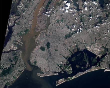
Army Corps projects in 1925 and 1932 extensively modified the upper Hudson Estuary for navigation. Forty two percent of the shoreline has been hardened with concrete or wooden barriers. Dredge material disposal from deepening eliminated 57% of the estuaries’ shallows and 30% of the river’s surface has been lost. These modifications were successful from the standpoint of navigation but detrimental from the environmental perspective. The navigational modifications increased turbidity, reduced habitat complexity, reduced water exchange with wetlands, and threw up barriers to aquatic/terrestrial migration. Bulkheading impedes wetland migration in response to sea level rise.[4]
Fresh sediment is necessary for animal habitat, for animal reproductive strategies, and for successful plant communities. New sediment will be needed to raise and expand tidal wetlands. The amount of sediment required to maintain the Estuary’s bathymetry in the face of sea level rise of 1-3 mm per year is 300,000 tons per year.[9] A linear regression based on 18 years of seal level data at Poughkeepsie [24] shows an average sea level rise of 4.7 mm per year. The Sea Level Rise Task Force predicts the rate of sea level rise to increase from six to ten-fold over the course of the 21st Century. [20] A USGS report using four years of data collected with an Acoustic Doppler Current Profiler at Poughkeepsie estimated 730,000 tons of sediment per year moving seaward. [25] While the current rate of sediment delivery to the Estuary may suffice to maintain its functions, future needs might not be satisfied at the current rate of sediment loading.
Diffuse and erratic sediment sources makes estimating loads extremely difficult. Suspended sediment measurements are laborious and very inefficient. Quantification of trivial loads occupies the vast majority of time devoted to sediment monitoring. Investigators rarely measure that part of the total sediment load rolling or bouncing along the channel bottom, called bedload. Significant sediment loading events occur unpredictably and rarely. Between 2004 and 2010 half the total suspended sediment came out of the Mohawk River in 22 days and four storm or melt events. Without continuous monitoring, capturing the rare event is extremely unlikely. Furthermore, the location of significant sediment loads varies with storm tracks. Destruction of sampling equipment by extreme events presents another hazard.
Alternatives to direct measurement of sediment transport include use of surrogates; water discharge and turbidity, and land cover models. Surrogates have proven highly unreliable without a great deal of coincident physical sampling for calibration. Land cover models relate forest cover, various kinds of farm lands, degrees of imperviousness, slope, rainfall and snow melt patterns, and soil type to sediment delivery. These models can be informative but fail to capture events.
The New York City Department of Environmental Protection and their County Soil and Water Conservation District partners have conducted intensive surveys as part of the Filtration Avoidance program. This is the largest and most technically sophisticated program of stream restoration in the region. It deserves attention as a possible model for evaluating other parts of the watershed. Stream reaches are walked by trained observers with a GPS, surveying equipment, and an extensive Data Dictionary. The Data Dictionary covers all the relevant features within 32 groups. Each grouping contains defined elements that the observer counts or measures. For example, there are 62 land cover classes and the bank erosion hazard index has 13 attributes. These field observations are collected into a GIS database for further evaluation.[14] Some of these data, such as meander frequency, come from aerial imagery but others (stream type, bankfull discharge, bankfull width, bankfull depth, bankfull cross section area) require careful measurements made on the ground. These statistics are used in restoring streams to reduce erosion and turbidity. The cost of NYCDEP’s remediations average $195 per foot. An analysis of three restorations on the Batavia Kill reported a 74% reduction in erosion.[3] More quantitative evaluations of restoration projects are a monitoring need. Stream restoration in the thinly populated Catskills may be impossible to replicate in more densely inhabited regions where utilities, roads, and development severely constrain stream morphological changes.
Cornell University’s Stream Health and Vulnerability model uses land cover characteristics, soil type, and slope to predict “stream health” and “stream vulnerability”.[12] “Health” refers to the expected abilities of a land cover to perform the functions of groundwater filtering, sediment retention, erosion control and flood reduction. “Vulnerability” estimates the contribution of riparian areas to runoff based on adjacent land cover, soils and slopes. The model uses a table of 26 land cover classes and four hydrologic soil groups to assess percent runoff values. The Health and Vulnerability models were applied to 43 sub-watersheds having an average area of 231 sq km and an average stream length of 311 km. There are 15,111 km of streams in the region of which 1,848 are of “Poor” or “Very Poor“ health and there are 5,179 km of streams that are “Highly” or “Very Highly” vulnerable.
If the remediation cost of $195 per foot, as was paid by NYCDEP, was applied to all the Very Highly Vulnerable streams in the Hudson Estuary, the final bill would be $1.7 billion. Including Highly Vulnerable streams raises the price to $3.3 billion. Population densities higher in the Hudson River Estuary than where NYCDEP was working increase costs and constraints. A 1997 paper estimated the ecosystem services of estuaries at $9,240 per acre per year in 1994 dollars.[5] That would translate to $724 million per year for the Hudson Estuary. Ninety-two percent of the calculated services would be for nutrient cycling, a major role of the wetlands. The President’s Council of Advisors on Science and Technology has called for increased attention to valuing ecosystem services.[17]
Some observers argue that the rate of sediment delivery to the Hudson River Estuary is best evaluated by the presence of regionally appropriate species occurring at appropriate biomasses.[10] Satisfying the requirements of a proper biologic community requires a host of elements including an absence of physical barriers and pollutants, control of invasive species, seasonally appropriate temperatures and flow regimes, refugia for predation avoidance, the right mix of bottom particle size, water clarity sufficient for submerged vegetation and for successful predation, and adequate carbon and nutrient supply. [7] Biologic assessment involves a vast variety of kinds of observations many of which require a great deal of expertise.[6] The NYSDEC Stream Biomonitoring project has conducted periodic surveys of hundreds of stream segments throughout the state using 16 water quality indicators based on taxonomic identification and species abundances of macroinvertebrates. [15;16] Not surprisingly, the densely settled Lower Hudson has the highest rate of Moderately or Severely Impacted sites (19 percent) while the Upper Hudson and Mohawk sites are mostly (96 and 98 percent) Non- or Slightly Impacted. Factors causing impairments include sewage, nutrient enrichment, urban and non-point runoff, and sometimes, siltation. Thirteen sites in the Lower Hudson are noted as having some level of impairment due to siltation. There were four such sites in the Mohawk region and two in the Upper Hudson.
Biomonitoring assessments have required high levels of training and experience. Budgetary austerity reduces the ability of NYSDEC to perform this work. The Hudson River Estuary Program has begun enlisting citizen observers to help through WAVE (Wadeable Assessments by Volunteer Evaluators). Participants will be trained to recognize 13 “Most Wanted” and eight “Least Wanted” macroinvertebrates. Occurrence of four or more Most Wanted species is diagnostic of Unimpaired waters. An Unimpaired stream supports aquatic life but could include Slightly Impacted or Non Impacted streams. Presence of four or more Least Wanted species suggests, but is not definitive, water quality impairment. The limited professional staff at NYSDEC need not spend time at Unimpaired sites.
Sediment, seemingly a simple parameter, turns out to have complex economic and environmental links to much of what goes on in the entire watershed. Sediment supply that satisfies one set of interests can be too much for others. Managers have only limited abilities to control sediment availability. Ultimately, we trust that well-functioning environments, measurable in biological terms, will produce and move the right amount of sediment.
Reference List
1. A.Srauss-Wieder Inc. 2011. The Economic Impact of the New York-New Jersey Port/Maritime Industry 2010 . Source: New York Shipping Association, Inc., Access date: 12-22-2011. http://www.panynj.gov/about/pdf/port-economic-impact-2011.pdf.
2. Beerling, David J, Bailey, John P, and Conolly, Ann P. 1994. Fallopia Japonica (Houtt.) Ronse Decraene. Journal of Ecology 82 (4): 959-979.
3. Chen, Yanwei, Bhatia, S K, Buchanan, James, DeKoskie, Doug, and VanSchaack, Rene. 2005. Effectiveness of Stream Restoration in Reducing Stream Bank Erosion: The Case of Batavia Kill Stream Restoration Projects, New York. Source: ASCE Conf.Proc.doi:10.1061/40763(178)122, Access date: 1-11-2012. http://www.catskillstreams.org/pdfs/40763-6898.pdf.
4. Collins, M J and Miller, Daniel. 2011. Upper Hudson River Estuary (USA) floodplain change over the 20th century. River Research and Applications.doi: 10.1002/rra.1509.
5. Costanza, R, d'Arge, R, de Groot, R, Farber, S, Grasso, M, Hannon, B, Limburg, K. E., Naeem, S, O'Neill, R. V, Paruelo, J, Raskin, R. G, Sutton, P, and van der Belt, M. 1997. The value of the world's ecosystem services and natural capital. Nature 387: 253-260.
6. Davis, Wayne S and Simon, Thomas P. 1995. Biological Assessment and Criteria: Tools for Water Resource Planning and Decision Making. Boca Raton: Lewis Publishers.
7. Fanok, Su, DePhilip, Michele, Creveling, Ellen, DeLucia, Mari-Beth, and Moberg, Tara. 2010. A Freshwater Conservation Assessment For The Upper Delaware River Basin. The Nature Conservancy.
8. Forman, R. T. T., Sperling, D., Bissonette, J. A., Clevenger, A. P., Cutshall, C. D., Dale, V. H., Fahig, L., France, R., Goldman, C. R., Heanue, K., Jones, J. A., Swanson, F. J., Turrentine, T., and Winter, T. C. 2003. Road Ecology: Science and Solutions. Washington D.C.: Island Press.
9. Geyer, Rockwell W, Woodruff, Jonathan D, and Traykovski, Peter. 2001. Sediment Transport and Trapping in the Hudson River Estuary. Estuaries 24 (5): 670-679.
10. Karr, James R and Dudley, Daniel R. 1981. Ecological perspecitive on water quality goals. Environmental Management 5 (1): 55-68.
11. Kondolf, Mathias. 1997. Hungry Water: Effects of Dams and Gravel Mining on River Channels. Environmental Management 21 (4): 533-551.
12. Meixler, Marci. 2009. Mapping streamside health and vulnerability of the Hudson River Estuary watershed. New Paltz, NY: New York State Department of Environmental Conservation.
13. Muñoz, Gabriela R., Panero, Marta A, and Powers, Charles. 2008. Sources Of Suspended Solids To The New York/New Jersey Harbor Watershed. New York: New York Academy of Sciences.
14. NYCDEP. 2006. Stream Management Data Dictionary Guide. NYCDEP Stream Management Program.
15. NYSDEC (d). 2012. 30 Year Biological Trends Report. Source: New York State Department of Environmental Conservation, Access date: 2-12-2012. http://www.dec.ny.gov/chemical/78979.html.
16. NYSDEC (e). 2012. Stream Biomonitoring. Source: New York State Department of Environmental Conservaton, Access date: 2-12-0012. http://www.dec.ny.gov/chemical/23847.html.
17. PCAST. 2011. Report To The President Sustaining Environmental Capital: Protecting Society And The Economy. Source: Executive Office of the President President's Council of Advisors on Science and Technology, Access date: 1-15-2012. http://www.whitehouse.gov/sites/default/files/microsites/ostp/pcast_sustaining_environmental_capital_report.pdf.
18. RSM Workgroup. 2008. Regional Sediment Management Plan. Source: New York - New Jersey Harbor Estuary Program, http://www.harborestuary.org/reports/Reg_Sed_Mgmnt_Plan0908.pdf.
19. Schneider, Rebecca. 2009. Science-based Guidelines for Successful Roadside Ditch Management to Mitigate Floods, Droughts and Degraded Water Quality. Source: Penn State's Dirt and Gravel Roads Conference, September 22, 2009, Access date: 1-26-2012. http://www.dirtandgravel.psu.edu/Edu_Training/Workshops/2009/presentations/schneider.pdf.
20. SLRTF. 2012. Sea Level Rise New York Projections and Impacts. Source: New York State Department of Environmental Conservation, Access date: 1-14-2012. http://www.dec.ny.gov/energy/45202.html#Projections.
21. Syvitski, James P M and Milliman, John D. 2007. Geology, Geography, and Humans Battle for Dominance over the Delivery of Fluvial Sediment to the Coastal Ocean. The Journal of Geology 115 (1): 1-19.
22. Tavolaro, John. 2011. New York & New Jersey Harbor: Managing Dredging in a Post-Deepening World. Source: WEDA Eastern Chapter Annual Meeting, October 12, 2011, Access date: 10-12-2011. http://operations.usace.army.mil/nav/11OctWEDA/12_Oct_2011_WEDA_-_Tavolaro.pdf.
23. USACOE-NY District. 2011. NY/NJ Harbor Dredged Material Management Dredging Activities, Volumes and Placement Sites. Source: US Army Corps of Engineers, Access date: 12-2-2011. http://www.nan.usace.army.mil/business/prjlinks/dmmp/pdf/2011Table1.pdf.
24. USGS. 2003. Lower Hudson River Discharge and Sediment Flux. Source: U.S.Department of the Interior, U.S.Geological Survey Maintainer: New York District, Access date: 8-2-2004. http://ny.water.usgs.gov/projects/poused/index.html.
25. Wall, G. R, Nystrom, E. A, and Litten, S. 2008. Suspended sediment transport in the freshwater reach of the Hudson River Estuary in Eastern New York. Estuaries and Coasts 31: 542-553.
© 4/16/2012 Simon Litten